
Automotive simulation software specialist, rFpro, has developed a highly detailed digital model of a rural road network located near the village of Harbury in Warwickshire, UK. The model offers a multi-functional simulation solution for vehicle development, ranging from vehicle dynamics and automated driving, to powertrain and headlight tuning. It has already been adopted by an unnamed ‘major UK vehicle manufacturer’.
The digital twin spans 17.5km (11 miles) and includes more than 230 buildings, 190 selectable parking locations, 660 drain covers, and over 2,000 roadside objects, such as lampposts, road signs and traffic lights. These features combine to create an immersive experience for both human drivers and vehicle sensor systems.
The Harbury model has been created using survey-grade LiDAR data, ensuring a road surface accuracy of 1mm in height, making the model suitable for vehicle dynamics tuning. The virtual route contains typical rough British B-roads, replicating undulating corners and uneven surfaces.
The model also includes features such as speed bumps, reflective road studs (commonly known as ‘cat’s eyes’), drain covers, potholes, and bridge expansion gaps. These elements enable engineers to assess a vehicle’s ride comfort, steering response, and chassis behaviour in a highly accurate and repeatable environment.
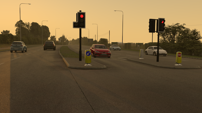
In addition to vehicle dynamics development, the model supports ADAS and autonomous vehicle testing with a variety of junctions, roundabouts, and challenging road layouts. The model is delivered with an OpenDrive network – allowing traffic scenarios and edge-case tests to be setup inside this virtual environment. The Harbury model has been built with integrated ground truth data, which is essential for ADAS system validation testing.
Through rFpro’s fully integrated simulation solution, AV Elevate, the Harbury model can be used to generate accurate synthetic training data for machine-learning algorithms. Users can randomise or specifically control pedestrians, traffic and parked vehicles, adjusting their type, colour, and even how dirty vehicles are, to create varied test scenarios. rFpro also enables full control over environmental conditions, including time of day, weather, and street lighting.
“Subjecting machine-learning algorithms to variety is critical to avoid overfitting the perception model,” stated Josh Wreford, AV Elevate product manager at rFpro. “For example, if you only subject a perception model to pedestrians in regular clothing, it will be confused when it comes across a worker in a high-visibility jacket. But this is also true for more granular details such as road markings and signs. We need to include the irregularities and nuances of the real-world – that’s why our digital models are perfectly imperfect.”
For example, although the length, width and spacing of road markings are dictated by regulations, in reality, they vary in size, fade, and don’t always meet exact specifications. As a result, the 2,900 road markings in the model, totalling more than 44km (27 miles) of paint lines, have been individually created to accurately replicate the real world.
The Harbury road route model is the latest addition to rFpro’s growing library of more than 190 digital models, which include public road routes, proving grounds, and race circuits.
“It is one of the biggest benefits of using simulation to develop vehicles,” concludes Wreford. “You can conduct tests on the busy streets of Los Angeles, the high-speed autobahns of Germany, undulating country roads of the UK, or even the streets of Monaco, all at the click of a button from the comfort of your own office.”


